


{{item.videoDuration}}
{{item.title}}
{{item.text}}

{{item.videoDuration}}
{{item.text}}
For energy and utility companies, keeping power lines and infrastructure free of obstructions can be crucial. Overhanging vegetation, unstable poles, sagging lines, damaged pipelines and corroded transformers are more than operational hazards. These conditions cause service interruptions, property damage, injuries, bad press and regulatory penalties.
The problem is rooted in a basic challenge: conventional inspection methods rely on manual processes, including crews walking or driving routes, snapping photos, scribbling notes and entering data into a business system. This approach can be slow, time-consuming and expensive. It’s also prone to errors.
Now, faster, smarter and more scalable inspections are within reach. Tapping into a modular, AWS cloud-first architecture, PwC has developed a solution that helps deliver real-time visibility into the condition of specific assets. Trucks, drones and conventional aircraft with mounted cameras and sensors can capture images and metadata. Artificial intelligence (AI) and machine learning (ML) help deliver deep insights.
Using high-resolution 2-D imagery, LIDAR, radar and 3D modeling, the system automatically captures data from various input sources so that an organization can assemble a more complete digital picture of physical assets. This includes capturing data in rugged and sometimes highly inaccessible terrain.
AWS cloud-native services handle compute, storage and machine learning tasks. This includes image enhancement and privacy protections (such as blurring sensitive data from license plates and property and redacting personal information), metadata tagging, geolocation, object identification and condition classification. The AI/ML models spot overloaded, damaged and broken poles, vegetation growing into power lines and damaged transformers.
Using Esri’s integrated Geographic Information System (GIS) platform, utilities have a straightforward way to connect asset condition data with interactive maps, dashboards, environmental overlays and business systems. The result is a unified view of assets, along with the ability to rank risks, prioritize work orders, dispatch field teams, plan long-term maintenance and react quickly and efficiently after a fire, earthquake, hurricane or other disaster.
Utilities can also harness digital twin technology. These virtual models of actual physical assets allow utilities to better understand asset life cycles, including anticipated maintenance and failure points. For example, an organization can model weather events, maintenance scenarios and how vegetation will likely encroach on wires, pipes or conduit over time. It can factor in regional variations in weather, plant growth and other variables.
The platform drives better planning, lower costs and more efficient operations. Business leaders have actionable information at their fingertips.
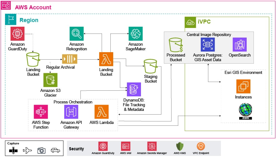
PwC’s remote inspection solution runs on cloud native services in AWS Cloud. This includes Amazon S3, AWS Lambda, Amazon SageMaker, and DynamoDB. These services support scalable batch processing for millions of image files annually. As batches of raw files arrive from drones and other sources, they’re initially dropped into the Landing S3 bucket, where they can be put to work. Within about a week, the images are moved to AWS Glacier storage for long term retention.
Image ingestion pipelines use a combination of services from AWS. This includes AWS Lambda, Amazon SQS, Amazon Rekognition, Amazon SageMaker, and Amazon DynamoDB. Images pass through several ingestion processing steps before they are loaded into the Esri GIS system. Along the way, Amazon Rekognition interrogates the images for object detection before they are run through additional AI or ML steps that ensures they match quality requirements. This includes:
As images pass through these various steps, the software builds a metadata store in Amazon DynamoDB. This data store serves two purposes. First, as the metadata is updated and assembled, it provides a thorough workflow monitoring capability. Second, with this metadata, users can search for images for use in additional model building and analysis.
Once image ingestion and processing has been completed, it’s placed in the processed S3 bucket, where it is accessible to the Esri GIS application environment — and users.
The Esri system runs on a fleet of Amazon EC2 instances and can be configured with auto-scaling to support load fluctuations. Already, PwC is working with several utilities as they migrate their Esri workloads into AWS, where the platform is delivering value.
PwC’s remote inspection solution continuously monitors and analyzes the condition of assets across vast geographic regions. It can reduce inefficient manual processes and labor-intensive tasks. Rather than providing a static and often out-of-date snapshot of assets, it helps deliver dynamic, current and actionable information — along with valuable insights.
Utilities that embrace this flexible and scalable solution can unlock powerful advantages: innovative image recognition, AI, machine learning and the advanced capabilities of the AWS cloud. They’re able to replace labor-intensive and error prone manual processes with intelligent automation — lowering costs, reducing risk and driving gains in efficiency. This isn’t just an improvement, it’s a transformation.
{{item.text}}
{{item.text}}


